


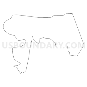
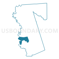
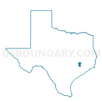
Voting District 0414, Waller County, Texas
About
Outline
Summary
| Unique Area Identifier | 678014 |
| Name | Voting District 0414 |
| County | Waller County |
| State | Texas |
| Area (square miles) | 18.52 |
| Land Area (square miles) | 17.98 |
| Water Area (square miles) | 0.54 |
| % of Land Area | 97.10 |
| % of Water Area | 2.90 |
| Latitude of the Internal Point | 29.90623950 |
| Longtitude of the Internal Point | -96.08090880 |
Maps

Graphs
Select a template below for downloading or customizing gragh for Voting District 0414, Waller County, Texas


Neighbors
Neighoring Voting District (by Name) Neighboring Voting District on the Map
- Voting District 0101, Austin County, TX
- Voting District 0311, Waller County, TX
- Voting District 0313, Waller County, TX
- Voting District 0415, Waller County, TX
Top 10 Neighboring County Subdivision (by Population) Neighboring County Subdivision on the Map
- Brookshire CCD, Waller County, TX (12,477)
- Bellville CCD, Austin County, TX (9,288)
- Hempstead CCD, Waller County, TX (9,261)
Top 10 Neighboring Unified School District (by Population) Neighboring Unified School District on the Map
- Sealy Independent School District, TX (13,101)
- Bellville Independent School District, TX (12,575)
- Royal Independent School District, TX (10,372)
- Hempstead Independent School District, TX (9,010)
Top 10 Neighboring State Legislative District Lower Chamber (by Population) Neighboring State Legislative District Lower Chamber on the Map
Top 10 Neighboring State Legislative District Upper Chamber (by Population) Neighboring State Legislative District Upper Chamber on the Map
Top 10 Neighboring 111th Congressional District (by Population) Neighboring 111th Congressional District on the Map
Top 10 Neighboring Census Tract (by Population) Neighboring Census Tract on the Map
- Census Tract 6802, Waller County, TX (9,966)
- Census Tract 6805, Waller County, TX (9,261)
- Census Tract 7605.02, Austin County, TX (5,104)